


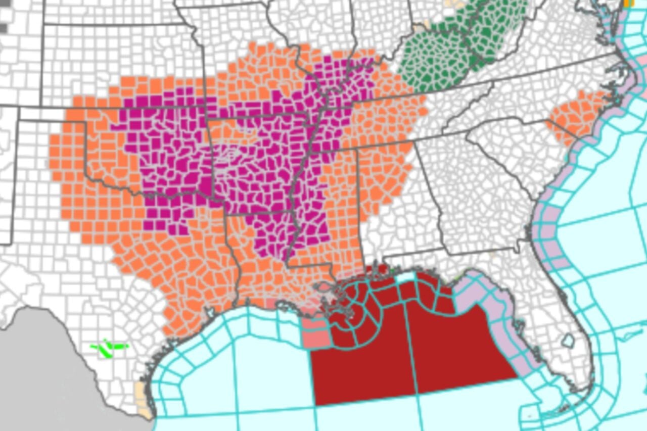
As Tropical Storm Bertha churns in the Gulf of Mexico, meteorologists say it isn’t the only weather threat the Southeast will face this week. A dangerous heatwave is expanding across the region, bringing triple-digit temperatures and humidity that could persist through the weekend.
On Tuesday morning, the National Weather Service’s (NWS) map of public alerts displayed heat-related advisories for parts of Texas, Oklahoma, Kansas, Louisiana, Arkansas, Missouri, Mississippi, Alabama, Tennessee, Kentucky, Indiana, and Illinois, as well as a tropical storm warning stretching from Louisiana to Florida.
In areas under heat advisories, sweltering conditions will settle in today. High temperatures and choking humidity could push feels-like temperatures to 105 to 115 degrees Fahrenheit (41 to 46 degrees Celsius) in some locations, with record-warm overnight lows of 75 to 80 degrees F (24 to 27 degrees C), according to the NWS.
Temperatures that high can be dangerous, especially when there is prolonged exposure. With the arrival of Tropical Storm Bertha, Gulf Coast residents run the risk of power outages, which could leave them temporarily without air conditioning amid this brutal heatwave. Here’s what you need to know.
Brace for Bertha
As of 11 a.m. ET on Tuesday, Bertha—the second named storm of the Atlantic hurricane season—was located in the northeastern Gulf of Mexico and had maximum sustained wind speeds of 60 miles per hour (97 kilometers per hour). Tropical storm force winds currently extend up to 90 miles (145 kilometers) outward from the center of the storm.
According to meteorologist Matt Lanza, Bertha should reach peak intensity today and then weaken as it approaches Louisiana. Still, the NHC expects the storm to produce significant total rainfall amounts of 2 to 4 inches with higher isolated totals of 6 inches through Thursday from western Florida to southern Louisiana, raising the risk of flash flooding—especially in urban areas. A coastal flood warning is also in effect for Mississippi and Louisiana, where storm surge could range from 1 to 4 feet (0.3 to 1.2 meters).
Tropical storm conditions should move westward from the Florida Panhandle to southeastern Louisiana late Tuesday through Wednesday, according to the NHC.
Earlier today, officials in New Orleans said the city’s sole power utility, Entergy New Orleans, is closely monitoring the storm and is preparing for severe weather that could impact its service. CenterPoint Energy is also preparing for storm-related outages across Houston.
“Re-affirming our all-hazards approach to emergency preparedness, our team continues to take critical actions to prepare for both the current Tropical Storm Bertha in the Gulf as well as the hottest temperatures of the season, including activating our Emergency Operations Center and mobilizing more than 1,050 frontline crew members to prepare for the impacts of these weather events,” Nathan Brownell, vice president of CenterPoint Energy, said in a statement.
When storms collide with sizzling heat
This week’s extreme temperatures will increase the likelihood of power outages in multiple Gulf Coast states. The combined impact of tropical storm conditions and severe heat will strain power grids and challenge utilities to keep up with surging energy demand and potential infrastructure damage from high winds and flooding.
At the same time, these temperatures will make any outages that do occur dangerous. Daytime feels-like temperatures, which account for both heat and humidity, could remain in the triple digits for several days with little relief overnight. This will increase the risk of heat-related illness and death for anyone without access to air conditioning.
Now is the time to identify the nearest cooling shelter just in case you lose power. You can also keep the temperature inside your home lower by closing your blinds during the day and making sure doors and windows are properly sealed. If you still have access to running water, taking cold showers or baths can further reduce the risk of heat-related illness.
The simultaneous arrival of this storm and a scorching heatwave underscores the growing threat of compound weather extremes, which are occurring more frequently due to climate change. Such events are particularly hazardous because their impacts on infrastructure and public health are multifaceted. Adapting to and preparing for them will be essential, especially in regions that are prone to multiple types of extreme weather.

